The Use of Declarative and Procedural Knowledge in Intelligent Navigation Displays
Brian H. Philips
George Mason University
4400 University Drive
Department of Psychology, m/s 3f5
Fairfax, Virginia 22030
+1 703 285 2156
bphilips@gmu.edu
ABSTRACT
One theory of environmental cognition suggests that both declarative landmark knowledge and procedural route knowledge are essential in structuring internal representations of the environment; such representations facilitate effective navigation in that environment [5, 7]. The proposed study will provide data to test this theory. The application that will be studied is an Advanced Traveler Information System (ATIS), which provides route guidance information to automobile drivers. Current route guidance systems incorporate only procedural route information in their route guidance displays (i. e., they give directions for getting to your destination without supplying landmarks to identify the route [e.g., 3]). This study will evaluate how the inclusion of landmark icons in ATIS displays affects users' navigation performance. The results will be important to ATIS developers, who need to know what informational elements to include in ATIS route guidance displays to most effectively support navigation tasks. The results will also be important in a theoretical sense, by testing a theory of environmental cognition with real-world navigation tasks.
Keywords:
ATIS, Declarative knowledge, Intelligent systems, ITS, Landmarks, Navigation, Procedural knowledge
INTRODUCTION
Mental representations of large-scale environments have been referred to as spatial images [7]. Spatial images are knowledge structures people use to mentally represent an environment, allowing them to navigate in this environment. Siegel and White [7] and Golledge [5] propose that two essential components of spatial images are declarative landmark knowledge and procedural route knowledge. Declarative knowledge is factual or conceptual knowledge that a person has, whereas procedural knowledge refers to how a person does something [1]. More specifically, declarative landmark knowledge is information a person has about the landmarks in an environment, whereas procedural route knowledge is the information a person needs to move from one location to another in an environment [5]. Both types of knowledge are needed to produce a detailed spatial image that people use to effectively navigate through their environment [5, 7].
Landmark Knowledge
A person's knowledge of an environment generally begins with noticing and remembering landmarks. People focus on landmarks when traveling, and use them as aids to help stay on course [7]. Procedural route knowledge consists of specific paths or routes through an environment, the ability to preview and process information to develop a travel plan, and heuristics to translate plans into spatial activity [4, 5]. Procedural knowledge builds on the declarative knowledge base by linking and translating this information into movement, which helps travelers move from one landmark to another.
Advanced Traveler Information System (ATIS)
An innovative technology currently being developed is the Advanced Traveler Information System (ATIS). ATIS is a computer-based, in-vehicle navigation system that plans the most efficient route and guides the driver to the desired destination using text and graphic displays. The efficacy of ATIS route guidance depends largely on how effectively this critical information is communicated to the driver [3]. Despite the importance of declarative landmark information for navigating [5, 7, 8], current ATIS interfaces present only procedural route guidance information to direct the driver to the desired location. Relatively little attention has been given to the potential contribution of landmarks to improving the effectiveness of route guidance displays. This work investigates the importance of such declarative knowledge to the design and efficacy of intelligent navigation displays.
LANDMARK KNOWLEDGE IN ATIS DISPLAYS
Few studies have investigated using both landmark and route knowledge in ATIS displays. Two studies suggest that drivers found landmarks very useful [6] and made fewer turn signal errors when navigating with landmarks [2]. However, these studies were limited in that they only included young adults in the sample [2] and only used traffic control devices (e.g., road signs, traffic signals) as landmarks [2, 6]. Therefore, the question of whether including landmark information to ATIS displays improves navigational performance has not been conclusively answered, and further study in this area is needed.
OBJECTIVES OF THIS RESEARCH
There are two main goals for this research. The first goal is to partially evaluate the theory of environmental cognition proposed by Siegel and White [7] and Golledge [5]. This study will evaluate their theory by first assessing whether adding landmark information to the route knowledge currently in an ATIS navigational display will improve navigational performance, in terms of accuracy and decision time. The landmark information incorporated in the navigational display will be landmark icons. The performance using the displays with landmark icons will be compared to navigation performance using displays with only route information. The second goal is to fill in some of the gaps in the ATIS research literature regarding the merits of landmark icons in route guidance displays, by investigating navigation under different visibility conditions, and including older drivers in the sample. By investigating new research issues, this study will provide ATIS designers with critical information on the effectiveness of landmark icons in route guidance displays, and the characteristics that contribute to effective landmark icons.
APPARATUS
This research is composed of two studies. The first study will use a standard IBM-compatible personal computer to assess subjects' comprehension of 24 different landmark icons (see Figure 1).

Figure 1. Three building landmark icons.
The second study will be conducted using the Highway Driving Simulator (HYSIM), at the U. S. Federal Highway Administration's Turner-Fairbank Highway Research Center in McLean, Virginia. The HYSIM is a high fidelity, fully interactive, fixed-based driving simulator. The HYSIM is essentially a car cab with a large screen positioned in front of the cab to display the computer-generated driving scenarios (see Figure 2).

Figure 2. Computer generated driving scenario, as viewed from the HYSIM car.
The steering wheel, accelerator pedal, brake pedal, and turn signal are functional, and have the feel of real controls. A computer displays ATIS navigational information on an LCD monitor located on the dashboard of the car (see Figure 3).
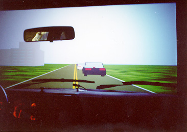
Figure 3. HYSIM cab with ATIS display and simulated driving scenario.
PROCEDURES
For the first study, 24 subjects will be shown landmark icons on a computer screen (see Figure 1). Recognition time and icon comprehension information will be recorded. The best icons from study one will be used in the ATIS displays for study two. For the second study, each of the 48 subjects will drive from an origin to a destination in one training route and six experimental routes that are completely unfamiliar to them in the driving simulator. During each route, there will be 16 intersections, where subjects will have to either go straight or turn. The ATIS route guidance display will show landmarks on some routes, and no landmarks on other routes. Participants will press a button to indicate which direction they will travel. Figure 4 shows an ATIS turn-by-turn display with a landmark icon incorporated into the display.
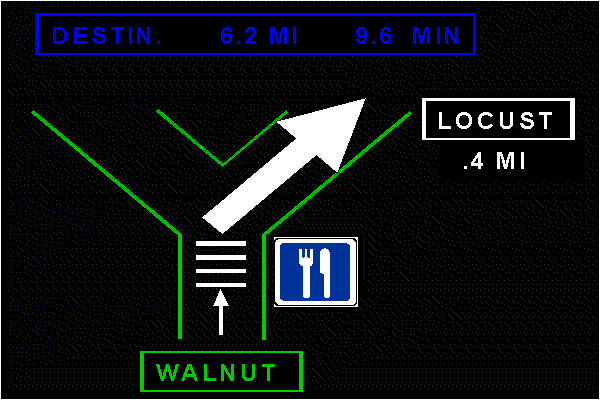
Figure 4. ATIS turn-by-turn display with landmark icon.
EXPERIMENTAL DESIGN
The first study is a one-factor, between-subjects design, that consists of showing subjects one of three versions of the eight different landmark icons. The second study is a 3 (Landmark Type) x 2 (Visibility) x 2 (Age) mixed-factors design. There are three different landmark conditions. In the first condition, the ATIS will have only traffic control device landmarks (e.g., a stop sign icon), in the second condition, only building landmarks (e.g., a church icon), and in the third condition, no landmarks. Participants will drive each of these three landmark conditions in both foggy and clear visibility conditions. The HYSIM will record how long subjects took to make a navigational (turn) decision and the accuracy of each decision.
SUMMARY
The goal of this research is to examine whether including both declarative landmark information and procedural route information in ATIS route guidance displays improves driver navigation. The results will be useful in both an applied and a theoretical framework. Designers of ATIS products will be interested in how additional environmental knowledge can improve the navigational efficacy of these devices. The results will also help clarify the relationship between declarative landmark information and procedural route information for navigational tasks.
ACKNOWLEDGMENTS
This research is sponsored by the U. S. Federal Highway Administration, Turner-Fairbank Highway Research Center, McLean, VA (Contract DTFH61-94-C-00003). I would like to thank Deborah Boehm-Davis (GMU) and Elizabeth Alicandri (FHWA) for their assistance on this project.
REFERENCES
- Anderson, J. R. (1993). Rules of the Mind. Hillsdale, N.J.: Lawrence Erlbaum.
- Bengler, K., Haller, R., and Zimmer, A. (1994). Experimental optimization of route-guidance information using context information, in ERTICO (Ed.), Proceedings of the First World Congress on Applications of Transport Telematics and Intelligent Vehicle-Highway Systems, Artech House: Boston, 1758-1765.
- Dingus, T.A., Carpenter, J.T., Fleischman, R.N., Szczublewski, F.E., Krage, M.K., and Means, L.G. (1991). Human factors engineering the TravTek interface, Vehicle Navigation & Information Systems Conference Proceedings, Society of Automotive Engineers, Warrendale, PA, 749-756.
- Garling, T., Book, A., and Lindberg, E. (1985). Adult's memory representation of their everyday physical environment. In R. Cohen (Ed.), The Development of Cognition (pp. 141-184). Hillsdale, N.J.: Lawrence Erlbaum.
- Golledge, R. G. (1991). Cognition of physical and built environments. In T. Garling and G. W. Evans (Eds.). Environment, Cognition, and Action. New York: Oxford University Press.
- Green, P., Hoekstra, E. and Williams, M. (1993). On-the-Road Tests of Driver Interfaces: Examination of a Route Guidance System and a Car Phone, Technical Report UMTRI-93-35, The University of Michigan Transportation Research Institute.
- Siegel, A.W., and White, S.H. (1975). The development of spatial representation of large-scale environments, In H.W. Reese (Ed.), Advances in Child Development and Behavior, Vol. 10, New York: Academic Press.
- Streeter, L.A. and Vitello, D. (1986). A profile of drivers' map reading abilities. Human Factors, 28, 223-239.
(c) 1997. Copyright on this material is held by the author.